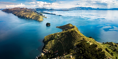
Lake Titicaca, the highest lake navigable to large vessels in the world, is also the second-largest lake in South America. Located between Peru and Bolivia, it has an elevation of 12500 feet above sea level.
Lake Titicaca lies between Andean ranges in a vast basin—about 22,400 square miles (58,000 square km) in area—comprising most of the Altiplano (High Plateau) of the central Andes. It covers some 3,200 square miles (8,300 square km) and extends in a northwest-to-southeast direction for a distance of 120 miles (190 km). The lake has an average depth of between 460 and 600 feet, but in the northeast corner of the lake, toward the Bolivian shore, the bottom tilts sharply, reaching the lake’s greatest recorded depth of 920 feet (280 meters).
The average surface temperature is 56 degrees Celsius, while the temperature at 66 feet deep drops to 52 degrees Celsius. Overall, Lake Titicaca is a vast and unique body of water, notable for its elevation, size, and depth, making it a significant geographical feature.


Lake Titicaca
Lake Titicaca
Lake Titicaca
Works Cited:
App.goo.gl, 2024, images.app.goo.gl/Lma2Lwvn46FJUz8B6. Accessed 14 Mar. 2025.
The. “Lake Titicaca | Description, Elevation, Map, & Facts.” Encyclopedia Britannica, 20 July 1998,
www.britannica.com/place/Lake-Titicaca. Accessed 7 Feb. 2025.
“The Lost Temples of Lake Titicaca: Exploring the Less Developed ...” Www.google.com, 2024,
images.app.goo.gl/4xYhTP3mRGmpZiTX8. Accessed 14 Mar. 2025.